Bayview Map

Bayview Map

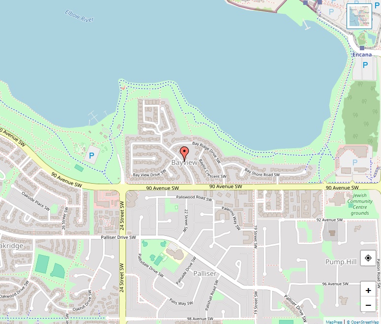
Located in the southwest quadrant of Calgary, Alberta, Canada, Bayview is a small yet picturesque residential area characterized by its exclusive position on a peninsula along the southern shore of the Glenmore Reservoir. Established in 1967, the community represents the epitome of suburban living with a touch of luxury. Location and Government Bayview falls under … Read more

Bankview Map

Bankview Map

Bankview offers a harmonious blend of the old and the new, the traditional and the contemporary. With a history dating back to the 19th century, this residential area has evolved over the years to become a bustling neighbourhood that retains its historic charm. Geographical Location and Connectivity Situated southwest of the high-density Beltline district, Bankview … Read more

Banff Trail Map

Banff Trail Map

Located in the northwest quadrant of Calgary, Alberta, Banff Trail is a welcoming residential community that combines the best of both urban and suburban lifestyles. With the University of Calgary to its west and the Southern Alberta Institute of Technology (SAIT) to its south, the community offers an academic atmosphere that is perfect for students, … Read more

Auburn Bay Map

Auburn Bay Map

Auburn Bay is a suburban residential neighborhood bustling with life and opportunities for outdoor recreation. Bordered by Seton Boulevard to the south, Deerfoot Trail to the west, 52 Street E to the east, and Stoney Trail to the north, the community is strategically positioned for both convenience and scenic beauty. Accessible Healthcare and Transportation One … Read more

Aspen Woods Map

Aspen Woods Map

Aspen Woods is a residential enclave known for its upscale atmosphere and expansive properties. Governed by Ward 6 under the stewardship of Councillor Richard Pootmans, the community is one of the city’s more recent developments, established in 2001 on land that was annexed back in 1956. A Community of Growth According to the City of … Read more

Arbour Lake Map

Arbour Lake Map

Situated in the northwest quadrant of Calgary, Alberta, Arbour Lake is a residential neighbourhood that brings natural beauty and suburban comfort together. Bordered by Country Hills Boulevard to the north, Crowchild Trail to the south, Nose Hill Drive to the east, and Stoney Trail to the west, Arbour Lake enjoys a strategic location under the … Read more

Applewood Park Map

Applewood Park Map

Nestled in Calgary’s southeast quadrant, Applewood Park serves as a tranquil residential neighbourhood offering a distinct yet integrated experience for its residents. With a prime location marked by coordinates 51°02′41″N 113°55′42″W, this area falls under the governance of Ward 9, represented in the Calgary City Council by Councillor Gian-Carlo Carra. A Community Defined Applewood Park … Read more

Alyth/Bonnybrook/Manchester Map

Alyth/Bonnybrook/Manchester Map

Set against the backdrop of Calgary’s bustling southeast quadrant, Alyth/Bonnybrook/Manchester stands as a unique fusion of industrial and residential environments. Though overshadowed by its more residential neighbours, this diverse area is an unsung hero contributing to Calgary’s economic and community life. Geographical Coordinates and Administrative Details Occupying a prime location marked by coordinates 51°01′14″N 114°01′26″W, … Read more

Altadore Map

Altadore Map

Nestled in the heart of Calgary’s vibrant southwest quadrant lies Altadore, a community that seamlessly combines the allure of traditional Calgary living with the benefits of modern urban sophistication. Established in 1945 and enriched by decades of history and community spirit, Altadore is much more than just a residential area; it’s a lifestyle. Location and … Read more

Albert Park/Radisson Heights Map

Albert Park/Radisson Heights Map

Explore Albert Park/Radisson Heights, a unique residential neighborhood in the southeast quadrant of Calgary, Alberta. Established in 1910, this community is rich in history and amenities, making it an ideal place for a diverse group of residents. Key Features: Location: Southeast Quadrant of Calgary Area: 1.7 km² Elevation: 1,085 m Population (as of 2006): 6,098 … Read more