Legacy Map

Legacy Map

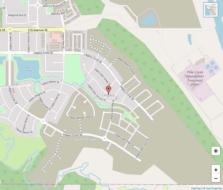
Situated in the southeastern quadrant of Calgary, Alberta, Canada, Legacy is a residential neighborhood known for its strategic location and growing community. Bordered by Calgary’s southern boundary with Foothills County, the neighborhood is easily accessible, being east of Macleod Trail, south of Walden, and west of the Bow River. The Hamlet of Heritage Pointe lies … Read more

Lakeview Map

Lakeview Map

Situated in Calgary’s southwestern quadrant, Lakeview is a residential neighborhood renowned for its picturesque setting and close proximity to Glenmore Reservoir. Bordered by Glenmore Trail SW, Crowchild Trail SW, and 37th Street SW, Lakeview enjoys easy access to major roadways while maintaining a serene community atmosphere. Boundaries and Surrounding Areas Lakeview is defined by its … Read more

Kingsland Map

Kingsland Map

Kingsland is a welcoming residential neighbourhood located in the southwest quadrant of Calgary, Alberta. The community enjoys a strategic position, surrounded by major roadways, which facilitates ease of access and connectivity for its residents. Location and Boundaries Coordinates: 50°59′24″N 114°04′42″W Quadrant: Southwest (SW) Ward: 11 Kingsland’s borders are defined by major roadways, ensuring the neighbourhood … Read more

Kincora Maps

Kincora Maps

Kincora is a vibrant residential neighbourhood situated in the northwest quadrant of Calgary, Alberta. Located near the city’s northern edge, Kincora offers its residents a serene yet well-connected living experience. Geographic Location Coordinates: 51°09′36″N 114°08′06″W Quadrant: Northwest (NW) Ward: 2 Boundaries The community is strategically bordered by other neighborhoods and major roadways, ensuring easy access … Read more

Killarney Maps

Killarney Maps

Killarney/Glengarry, commonly referred to as Killarney, is a vibrant residential neighbourhood located in the southwest quadrant of Calgary, Alberta. With a rich history dating back to 1906 and a diverse selection of amenities and services, Killarney offers residents a balanced urban-suburban lifestyle. Geographic Location Coordinates: 51°01′54″N 114°07′36″W Quadrant: Southwest (SW) Ward: 8 Elevation: 1,120 m … Read more

Kelvin Grove Maps

Kelvin Grove Maps

Nestled in the southwest quadrant of Calgary, Alberta, Kelvin Grove stands as a peaceful residential neighbourhood, offering its residents a tranquil living environment with convenient access to essential amenities. With its establishment dating back to 1957, the community has matured into a stable and welcoming enclave within the bustling city of Calgary. Boundaries and Location … Read more

Inglewood Maps

Inglewood Maps

Located in central Calgary, Alberta, Inglewood is a neighborhood that thrives with history, arts, and a robust sense of community. Its urban setting, near the Elbow River and downtown Calgary, makes it a popular destination for both residents and tourists. History and Development Inglewood holds the title of Calgary’s oldest neighborhood, established in 1875, shortly … Read more

Huntington Hills Maps

Huntington Hills Maps

Nestled in the northwest and northeast quadrants of Calgary, Alberta, Huntington Hills stands as a vibrant residential neighbourhood. Established in 1967, it has grown to be a community that offers a range of amenities and services to its residents. Location and Boundaries Huntington Hills is strategically located and is bounded by Beddington Boulevard to the … Read more

Hounsfield Heights/Briar Hill Maps

Hounsfield Heights/Briar Hill Maps

Hounsfield Heights/Briar Hill is a well-established, inner suburban neighbourhood located in the northwest quadrant of Calgary, Alberta. Renowned for its stunning views of downtown Calgary and the Rocky Mountains, this community has become a desirable place to live for many. Location and Accessibility The neighbourhood is strategically situated, with its boundaries marked by 16th Avenue … Read more

Hotchkiss Maps

Hotchkiss Maps

Hotchkiss, a suburban residential neighborhood situated in the southeast quadrant of Calgary, Alberta, represents the evolving face of Calgary’s residential landscape. With its strategic location and ongoing development, it is poised to become a thriving community. Geographic Location Hotchkiss is conveniently located, bounded by Marquis of Lorne Trail SE (Highway 22X) to the south, Stoney … Read more